- On This Page:
- On Cape Island
- Scenic Walks
- Beyond Cape Island
On Cape Island
You don’t have to leave the island to find room to roam. Cape May, West Cape May and Cape May Point are home to a surprisingly varied collection of trails, with landscapes that shift from lighthouse ponds and coastal dunes to open meadows, salt marsh and woodland.
Cape May Point State Park
Start beneath the Cape May Lighthouse, then head beyond one of Cape May Point’s most recognizable landmarks into a landscape of ponds, freshwater marsh, dunes and beach.
Six blazed trails cross the park. The Duck Pond, Monarch and Plover trails form the three primary routes, while three shorter paths provide opportunities to branch off, connect trails or add a quick detour.
Link to Trail BrochureLink to Trail Map and BrochureLink to AllTrails
Cape May Point State Park
Easy Trail Loop 0.5 Miles
Beginning on the east side of the parking lot, the red-blazed Duck Pond Trail follows an accessible boardwalk to Lighthouse Pond West and East. Platforms along the water offer places to stop and look across the ponds before continuing through the park.Easy Trail Loop 1.2 Miles
Continue farther into the park on the yellow-blazed Monarch Trail. The partially boardwalked loop passes through several different habitats, including freshwater marsh, coastal dunes and beach.Easy Trail Loop 1.5 Miles
The blue-blazed Plover Trail is the longest of the park’s three main routes, looping through the ponds and beach dunes. It also brings walkers toward neighboring South Cape May Meadows, where it’s possible to continue exploring rather than turn back.Easy Trail Spur 0.1 Miles
Branch from the Duck Pond Trail onto this short boardwalk. The trail leads toward Lighthouse Pond, with one of the park’s most distinctive views of the lighthouse beyond the surrounding wetland.Easy Trail Spur 0.2 Miles
The Raptor Trail serves as a short connection between the Monarch and Plover trails, giving walkers another way to move through the larger trail system.Easy Trail Spur 0.2 Miles
Take this short trail spur from the Plover Trail toward Cattail Pond. Conditions can change here, and the trail may occasionally be muddy or flooded.


South Cape May Meadows Preserve
Just beyond Cape May Point State Park, the landscape opens up at South Cape May Meadows. Freshwater wetlands, ponds, fields and dunes stretch toward protected beachfront, with the Cape May Lighthouse still visible beyond the preserve.
There are more than two miles of trails to explore. An approximately one-mile loop offers a straightforward way to see the Meadows, while additional paths can extend the walk or carry you directly into Cape May Point State Park.
Link to Trail Map and BrochureLink to AllTrails
South Cape May Meadows Preserve
Easy Main Loop 0.4 Miles
One of the preserve’s primary routes, the Main Trail follows compact crushed stone through the Meadows and toward the dunes.
Easy Trail Spur 0.6 Miles
The Boardwalk Trail travels through a portion of the preserve that was previously less accessible. The wide, flat route includes pullout areas with benches along the way and is designed to accommodate wheelchairs and strollers. Easy Main Loop 0.15 Miles
This short connector joins the Main and East trails, allowing the two to be combined into an approximately one-mile loop through the preserve.Easy Main Loop 0.49 Miles
The East Trail travels through the eastern side of the preserve, with views across the freshwater wetlands along the way.Easy Trail Spur 0.3 Miles (One Way)
Extend the eastern side of the trail network along this sand-and-grass spur before returning to the main trails.Easy Connector Trail 0.2 Miles
Not ready to turn around? The State Park Connection Trail links the Meadows with the trail system at Cape May Point State Park, making it possible to explore both areas in one outing. 


Garrett Family Preserve at Cape Island Creek
Garrett Family Preserve is less about choosing one route and more about seeing where the paths take you. Trails weave across open meadows, fields and tree lines before reaching the salt marshes of Cape Island Creek.
More than four miles of sturdy nature trails cross the 180-acre preserve, giving you plenty of room to piece together a walk of your own. Benches and picnic tables throughout the property also offer places to stop along the way.
Link to Trail Map and BrochureLink to AllTrails
Easy Main Loop 1.4 Miles
Circle much of the property on the longest individual trail in the preserve. Along the way, the Perimeter Trail meets several of the shorter interior paths, making it a natural starting point for exploring more of the trail system.
Easy Connector Trail 0.4 Miles
Use the Loop Connector to move between different sections of the preserve or create a shorter route through the property.
Easy Connector Trail 0.3 Miles
A short interior path that can be worked into a longer route through the preserve.
Easy Connector Trail 0.2 Miles
At just 0.2 miles, Poet’s Trail is one of the preserve’s shortest paths and can easily be added to a larger walk.
Easy Connector Trail 0.3 Miles
Another short route through the preserve, connecting with the surrounding trail network.
Easy Connector Trail 0.3 Miles
The Butterfly Trail passes through a landscape where native plants and wildflowers provide habitat for butterflies and other pollinators.Easy Connector Trail 0.4 Miles
Follow the transition between two of the preserve’s defining landscapes on this route connecting marsh and meadow habitat.


Cape May
Cape May Nature Trail at Lafayette Street Park
Easy Main Loop 0.5 Miles
Not every nature walk needs to become a whole-afternoon excursion.
The Cape May Nature Trail at Lafayette Street Park follows an approximately half-mile loop close to the center of town. Give yourself around 30 minutes for a walk through the park, making this one particularly easy to work into a day already spent around Cape May.
There isn’t an official trail map yet, so there’s little need to overplan this one—just follow the loop and enjoy a quieter pocket of town.
Link to Trail Info at CapeMay.com
Link to SouthJerseyTrails with GPS Track

West Cape May
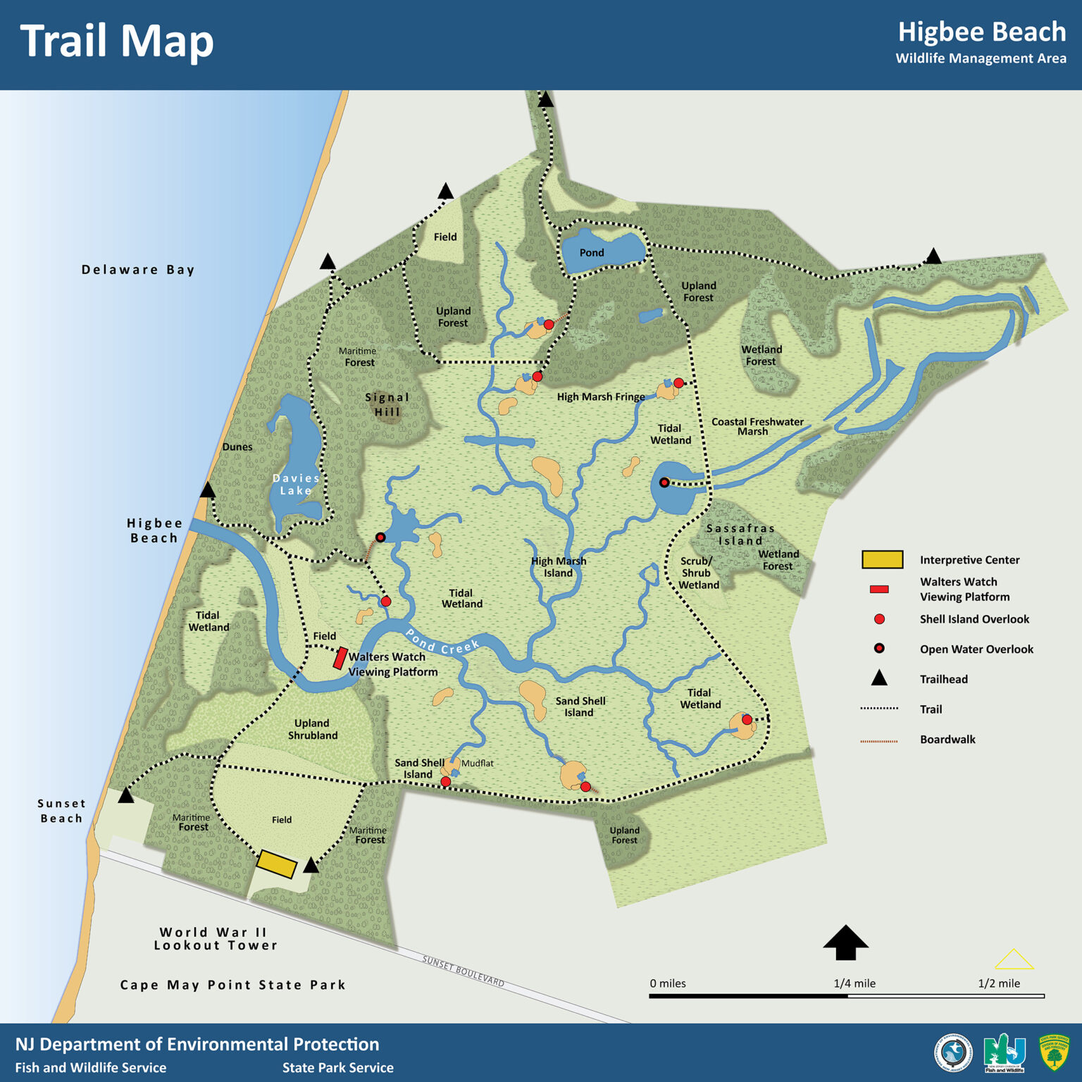
Higbee Beach Wildlife Management Area
Easy to Moderate Main Loop 2.2 Miles
For a longer walk in a more natural setting, head toward Higbee Beach Wildlife Management Area on the western side of Cape Island.
A popular loop through the area covers approximately 2.2 miles, with an estimated walking time of about 30 minutes to one hour. The route moves through a mix of woodland, marsh and shoreline habitat, offering a different experience from the more structured trails around Cape May Point.

Scenic Walks Around Cape May
Not every good walk requires a trail map. Around Cape May, the shoreline can become the route, a favorite destination can give you a reason to keep going, and a landmark climb can add a few extra steps along the way.
Cape May
Cape May Promenade
Easy One Way 1.45 Miles
Follow the Promenade along Beach Avenue with Cape May’s beaches beside you. Walk the full length and return for just under three miles, or simply turn around whenever you’ve had enough.

Cape May to Cape May Point
Cove Beach to Cape May Lighthouse
One Way 4 Miles
Trade the Promenade for the sand and follow the shoreline from The Cove toward Cape May Point. With the Cape May Lighthouse as your destination, the busy beachfront gradually gives way to the coastal landscape surrounding the Point.
Seasonal wildlife protections may affect portions of the beach, particularly around South Cape May Meadows, so follow posted signs and nesting-area closures as you go.

West Cape May
Sunset Beach to Higbee Beach
One Way 1.5 Miles
Follow the Delaware Bay shoreline from Sunset Beach toward Higbee Beach for a shorter walk on the island’s western side.
As restoration work continues around portions of Higbee Beach Wildlife Management Area, check current access before choosing this route.
While seldom seen, if you're supremely lucky, you might even catch a glimpse of Cape May's "Ghost Tracks."

Cape May to West Cape May
Congress Hall to Beach Plum Farm
One Way 2.2 Miles
Sometimes the destination is the best part of the walk. This route is one of the best ways to experience the shift between Cape May’s seaside streets and the farmland just beyond them—and there’s something waiting for you when you get there.

Cape May Point State Park
Cape May Lighthouse Climb
199 Steps 10-15 Minutes
If you’re already exploring the trails at Cape May Point State Park, head up before you leave. The Cape May Lighthouse climb covers 199 steps to the top, with views across the Point and surrounding coastal landscape.

Sunset Boulevard
World War II Lookout Tower
50 Steps 5-10 Minutes
Pair a walk along the western side of Cape Island with a short climb inside the World War II Lookout Tower near Sunset Beach.

Beyond Cape Island
There’s enough to explore on Cape Island to keep your walking shoes busy for days. Venture beyond it, though, and the setting begins to change. The protected coastline continues, but there are also larger wildlife areas, wooded preserves, swamp forest and, farther north, miles of trails through Belleplain State Forest.
Cape May National Wildlife Refuge
Easy to Moderate A Diverse Collection of Trails Across Multiple Locations Total of 4 Miles
Cape May National Wildlife Refuge isn’t a single park with one trailhead. Its trails are spread across the Delaware Bay Division, Great Cedar Swamp Division and Two Mile Beach Unit, each showcasing a different piece of the Cape May County peninsula.
That means this is one destination where it helps to decide what you want to see before getting in the car.
Wildwood
Our Pick: Two Mile Beach Unit Trails
This division of Cape May National Wildlife Refuge is situated not far from Cape May. Made up of four short trails totaling just under a mile, this network of trails traverses marshland, dunes, and beaches.
The Marsh Boardwalk Trail leads toward an observation platform overlooking the salt marsh, providing a short route with a clear destination.
The Northern Dune Trail is one of the longer paths within the Two Mile Beach trail network traversing along the dunes onto the beach.
The Southern Dune Trail is a shorter option through the unit’s protected coastal landscape.


Cox Hall Creek Wildlife Management Area
Easy to Moderate A Collection of Loops, Trail Spurs, and Connector Trails Total of 4 Miles
Once part of a golf course, Cox Hall Creek Wildlife Management Area is now 322 acres of protected coastal habitat in Lower Township. Its color-coded trails travel through the property, with connector paths making it possible to combine several routes during one visit.
Link to Trail MapLink to AllTrails
Lower Township
Our Pick: Cox Hall Creek Outer Loop
The Cox Hall Creek Outher Loop traverses through open meadows, wooded edges and around the property’s ponds. Much of the route follows the former golf-course paths, giving it a wide, mostly paved surface that also makes it popular with cyclists and families with strollers.
The outer loop is a good way to take in the preserve as a whole without needing to piece together several of the shorter interior trails. During warmer months, bug spray may be worth bringing if you plan to linger near the water or stay out later in the day.

Lizard Tail Swamp Preserve
Easy to Moderate One Main Loop and Connector Trail Total of 3 Miles
Lizard Tail Swamp Preserve contains about three miles of foot trails through fields, forest and wetland habitat, with two primary routes providing a straightforward choice of distance.
Link to Trail MapLink to AllTrailsMiddle Township
Our Pick: Yellow Trail
The Yellow Trail is the main loop through the preserve. Enjoy amenities throughout the trail such as an information kiosk, picnic tables, benches, and footbridges.
Should you want to continue, The Blue Trail covers another mile or so through the preserve. You can start this connector at the trailhead or turn off where it intersects with the Yellow Trail further into the preserve.


Belleplain State Forest
Moderate to Challenging A Collection of Loops, Trail Spurs, and Connector Trails Total of 47 Miles
Farther from the shoreline, Belleplain State Forest offers a different scale for those eager to explore further.
The forest has 24 official trails. Twelve, covering approximately 24 miles, are designated for nonmotorized use, while another 12 cover approximately 23 miles and permit road-legal motor vehicles. Rather than try to fit the entire network into one visit, we encourage you to choose a route that works for the time you have and use the full forest map to explore the rest.
For a longer day on foot, these trails cover considerably more ground than the walks closer to Cape May.
Link to Trail Map and Brochure Link to AllTrails
Belleplain State Forest
Our Pick: East Creek Trail
The white-blazed East Creek Trail begins at the Lake Nummy Day Use Area and loops through the forest toward East Creek Pond. The trail ranges from roughly two to four feet wide and follows a natural surface of sand, dirt and pine needles. At nearly seven miles, it is the longest hiking trail in Belleplain State Forest.
Give this trail more time to explore. Bring water, look over the trail map before starting and let the forest—not the next stop on the itinerary—set the pace.

See Cape May One Step at a Time
There isn’t one way to explore Cape May on foot.
A morning might mean half a mile near downtown or a stroll along the promenade. Another day might take you from South Cape May Meadows into the State Park, across several intersecting paths at Garrett Family Preserve or along the sand with the lighthouse in the distance.
When you’re ready to go beyond Cape Island, there’s even more ground to cover—from the varied habitats of Cape May National Wildlife Refuge to miles beneath the trees at Belleplain State Forest.
All that’s left is deciding where to start.
Related Stories

The Art of Seaside Living
Discover how local Cape May photographer Joe Evangelista's artwork became a defining element of the Sandpiper Beach Club's renovation, creating a stronger connection...

Know Before You Go: A Cape Resorts Guide
Consider this a campus guide to navigating the full ecosystem: which property suits your travel style, where to eat, what to book ahead, and what is worth building your trip around.


Inside the Harvest Dinner Series at Beach Plum Farm
At Beach Plum Farm, what's on the menu is a direct reflection of what's fresh from the fields.